5. From Ice Age to Contact
Climate change around 1300 may have played a role in the shifting fortunes of other Indigenous civilizations. It was around this time that the Diné and Apache set out for the southwestern Plains and the Ancient Puebloan cultures—including the Anasazi—seemingly fell apart and/or migrated south to join with other peoples to create the “modern Puebloan” culture. And it was during the twelfth century, too, that the Nahua/Mexica were descending into the Valley of Mexico and the Inca were laying the foundations of their empire in Peru. Whatever the cause of the dispersal of Mississippian populations, the 1200s, 1300s, and 1400s witnessed a significant shift in agricultural societies, and some non-agricultural societies as well. Here, we’ll briefly survey what was happening in the Arctic, in the Eastern Woodlands, on the West Coast, and in the drainage basin of Hudson’s Bay.
Eastern Woodlands & Great Lakes
This period saw the rise of modern northeastern farming cultures like the Haudenosaunee (a.k.a. Iroquois), Wendat (Huron), Laurentian Iroquois (Hochelaga, Stadacona, and others), Tionontati (Pétun or Tobacco), Attawandaron (Neutral), and Erieehronon (Erie). These were all located in the basin of the Great Lakes east of Lake Huron and extending east to the Gulf of the St. Lawrence.
Mostly sedentary, these Iroquoian societies were heirs to the Mississippian agriculturalists and heavily dependent on the “three sisters.” They did not consistently get along with one another: feuds and wars occurred often enough for diplomatic solutions to become significant turning points in their historical record. In some accounts, this violence was bound up in “Mourning Wars,” episodes in which members of enemy communities were captured to take the place of individuals in Iroquoian populations who had died prematurely (from warfare, principally). Confederacies were one way to reduce the threat of war and improve the odds of diplomacy and defence. The Haudenosaunee Confederacy may have been established as early as 1142 CE, although some scholars dispute that date as perhaps as much as three hundred years premature. In the Haudenosaunee account, fractious relations between the Onondaga, Onyota’a:ka (a.k.a. Oneida), Kanien’kehá:ka (Mohawk), Gayogohó:no (Cayuga), and Seneca were ended through the efforts of an elderly statesman (Hayonhwatha, Hiawatha), a young diplomat known as “The Peacemaker” (Deganawidah), and an influential matriarch (Jigonhsasee).[1] In some accounts, Deganawidah arises in the Wendat villages to the north and begins a largely fruitless pilgrimage through the rival peoples of Southern Ontario, only achieving some success when he and his allies are able to bind the Five Nations into a “League of Nations” beneath the “Tree of Peace.” Whether founded in 1142 or 1450, the Haudenosaunee League remains one of the oldest modern political entities in North America.
The Iroquoian peoples—including the Haudenosaunee, but not only the Five Nations “People of the Longhouse”—lived in villages of a thousand or more. These were near-permanent sites of occupation: villages would be relocated every ten years or so as soil became exhausted. Significantly, these Eastern Woodlands Indigenous civilizations abandoned the mound-building practices of their neighbours/predecessors. The Iroquoian villages, instead, tended to be palisaded sites, fortified against attack, and surrounded by cornfields and other crops. They survived—no, thrived—on a mix of grown produce and fish (including and especially eels) and game. Their longhouses held multiple families and served, as well, as warehouses in which trade goods could be stockpiled. The Mississippian civilization might have disappeared, but their extensive networks and traditions of commerce did not go away.
The Iroquoian longhouse villages created and reflected tightly–knit communities in which decisions were made collectively but which were binding on no one without their consent. Independent action was both tolerated and respected; coercion in personal relations and diplomacy was not. While the Tree of Peace prohibited conflict between its members, it did nothing to stop, say, the Kanien’kehá:ka from independently attacking their Mahican neighbours. It is important to note, too, the critical role played by women in decision-making and in the councils of the Haudenosaunee, Tionontati, Attawandaron, and Erieehronon, and the Wendat at Wendake Ehen (a.k.a. Huronia). Although oratory in council was pretty much the monopoly of men, the judgment of women and their ability to direct council discussions was at least as influential. Gendered roles existed, but the Iroquoian sense of equality and personal worth appear over and over in the written and oral record.
Similar patterns of life could be found among the Laurentian or St. Lawrence Iroquois. These people entered the region around 1000 CE to take advantage of the good soil in the valley and its tributaries. Their two largest centres, Hochelaga and Stadacona, were likely comparable to the largest Haudenosaunee villages. The “Laurentian Iroquois” were, however, distinct peoples, even among themselves; they ought not necessarily be considered a single, let alone united, polity. We just don’t know for certain how they related politically to one another. What is almost certain is that all of these farming peoples were able—and happy—to trade their surplus food production with the hunter-gatherer peoples to the north. These other Indigenous communities were mostly Algonquian-speakers and included (from east to west) the Innu (a.k.a. Montagnais), the Omàmiwinini (Algonquin), and the Anishinaabe (Ojibwa). Some Algonquian-speaking peoples in the Northeast also pursued agriculture, but these were exceptions that proved the rule by the 1300s.
Populations (on which there is more below) were growing and moving in the post-1100 period. Conflict arose from many directions, and alliances were always being forged. The Haudenosaunee Confederation is one example, but there are others with far greater reach. The Council of Three Fires was struck as early as 796 CE at Michilimackinac between the Anishinaabe peoples—the Ojibwe (a.k.a. Ojibwa, Chippewa), Odawa (a.k.a. Ottawa), and Potawatomi—and occupied the lands of the Laurel Complex. The Wendat probably founded their confederacy early in the 1500s, and the Wabanaki (mostly in what is now the Maritime provinces) formed theirs around 1680. There is every likelihood that these alliances followed on earlier arrangements and that they were regularly renewed.
Anishinaabe tradition (some of which is preserved on the Midewiwin scrolls) has it that their people originated in the West, settled for many generations on the East Coast and, about two thousand years ago, began a return migration to the west. This migration—possibly set in motion by population pressures and said to have involved very large numbers of people—entailed the severing of links to Abenaki relations and the establishment of settlements along the way to the Great Lakes. These settlements—including one near what is now Montréal and another near present-day Detroit—may each have had a lifespan of hundreds of years. In other words, they weren’t mere camps but effectively “permanent” village sites in their own regard, and they were bases on which to build relations with Innu and Omàmiwinini. This “migration” was, then, a very long–term process, and one that forged a common cultural framework and economy across the region.
The Far North
An even more dramatic human movement was taking place roughly simultaneously in the Arctic. The Dorset culture appeared around 500 BCE and soon dominated the high Arctic, migrating across ice and islands from west to east until they reached the near shore of Greenland. Their economic and social order depended heavily on hunting on the ice in small family units. According to archaeological evidence, they were too slow to adapt to a warming trend beginning around 800 CE. By this time, as well, they were encountering pressure from other peoples who were taking advantage of changed environmental conditions. Competition came on their western fringe from the Thule culture—people who would subsequently create the Inuit culture—and on their southern margins by other Indigenous peoples (including Innu and possibly Beothuk). In a foreshadowing of events to come, the Dorset also found themselves competing for resources with Europeans. Vikings arrived in the area of Baffin Island and as far south as Newfoundland around 986–1020 CE. Recent evidence indicates a sustained (if seasonal) Viking presence on Baffin Island at Tanfield Valley and prolonged trade with the Dorset peoples.[2] If this new commercial relationship presented the Dorset with some new opportunities and advantages, it wasn’t sufficient. When the Little Ice Age took hold, the Dorset were reduced to marginal populations. They effectively disappeared around 1500 CE.
At this point, Thule culture had spent nearly 400 years adapting to conditions in the central and eastern Arctic. Their communities/villages were larger than those of the Dorset, sustained by a greater diversity of resources. Their toolkit and techniques won them success on the land and in open waters, as well as on the ice. They were, compared to the Dorset, virtuosos of their environment, even by 1300 CE. The Thule spread further south along the eastern shore of the Ungava Peninsula, where they encountered Innu peoples in what is now Labrador. The Thule/Inuit thus carved out a territory that stretched along coastlines and islands from Alaska to both shores of Greenland, much of Hudson’s Bay, and what is now Québec’s north coast. The fact that this was accomplished in the space of three hundred to four hundred years tells us a great deal about the speed at which human migrations can take place in largely hostile conditions. It is, thus, a compelling reply to the question of how it was that humans were able to occupy the whole of the Pacific coast in short order fifteen thousand or more years ago.
The Hudson’s Bay Drainage
East of the Rockies, there are four great drainage systems: the Great Lakes-St. Lawrence, the Missouri-Ohio-Mississippi, the Peace-Athabasca-Mackenzie, and the lands that drain into Hudson’s Bay. This last region includes much of the sub-Arctic, the woodlands, parklands, and prairies of the West, and everything north of the Shield, including what is now northern Québec. The Saskatchewan (North and South), the lakes of Manitoba, and the Red and Assiniboine Rivers are the largest features of this system, while the Moose, Albany, and Severn Rivers, and James Bay are also critically important to the history of human life—and, eventually, colonialism—in the North. Remarkably, one group came to dominate this huge empire: the Cree.[3] An Algonkian-speaking peoples, the Cree territory includes lowland and swampy regions rich in fur-bearing animals and fish, as well as parkland and woodlands where wood bison and other large mammals could be hunted. Their range extends onto the Plains, which could be both a more generous and a more stingy environment. There is uncertainty and debate as to when the Cree first arrived into this last territory—the Plains—and began to adopt the main features of Plains culture. Much of this way of life they evidently learned from their neighbours and allies, the Nakoda Oyadebi (a.k.a. Nakota, Assiniboine), a Siouan-speaking peoples who themselves were moving westward from ancestral places in what is now Wisconsin. Relations between the Nakoda Oyadebi and other Siouan-speakers were mostly poor, and the Nakoda Oyadebi opted to stay out of the Sioux Seven Fires Council, probably in the sixteenth century. Instead, they helped to forge with the Cree and the Nahkawininiwak (a.k.a. Saulteaux, Plains Ojibwa, Chippewa), an alliance known as the Iron Confederacy—likely an indicator of their early involvement in trade with the Europeans.
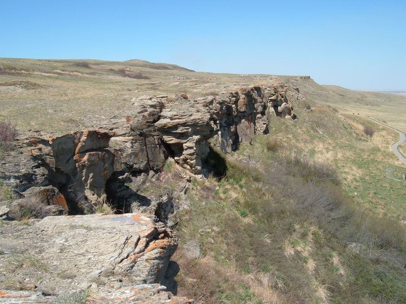
Most Plains societies evolved bison–hunting cultures that required coordinated and collaborative strategies. Bison are profoundly powerful animals, and one hunter with a spear poses little threat to an adult bison. Their herds, too, were so enormous prior to the nineteenth century that a confrontation on open ground would go very badly for a human on her or his own. Guile and deception with a little help from built infrastructure, topography, and families working in larger band units, however, could be highly effective. Buffalo jumps appeared across the Plains about 6000 BPE. The Head-Smashed-In Buffalo Jump site in southwestern Alberta first came into use about 5700 years ago, making it a contemporary of Peru’s Chico-Norte. It was used as a kill site where herds of bison were driven off of a 35-foot cliff, seriously injuring or killing the game outright. The bodies would then be hauled off to a nearby campsite and processed. The site remained in use for thousands of years, until relatively recently: excavations at Head-Smashed-In have unearthed a deposit of skeletons, measuring more than 10 metres (33 feet) deep. 7 Although all Plains peoples seem to have made use of bison jumps and pounds (a corral-like arrangement into which bison were painstakingly moved), the Niitsitapi in particular are associated with these practices.
The Northwest Coast
The Pacific coast—which is now considered to be one of the longest settled regions in the Americas—was already a quilt work of distinct cultures and languages two thousand years ago. There were more than thirty distinct languages spoken in what is now British Columbia, and a far greater number of dialects. These unique qualities are reflected, too, in cosmologies, artwork, ceremony, and engineering. But there are also important shared elements, many of which arose from the staple foodstuff that sustained so many populations in this region: salmon.[4]
Most easily captured in spawning channels, salmon could be harvested from Alaska to California. Their range took different species deep inland along the major rivers of the West Coast, including the Stikine, the Skeena, the Fraser, the Columbia, and the Sacramento. In this way, the peoples of the Cordillera—the highland plateaus that stretch across most of what is now British Columbia, Washington, and Oregon—were connected with their distant neighbours on the coast. So rich was the salmon resource that the region was home to some of the highest population densities on the continent.
The remains of one early and very large community have been excavated at Keatley Creek, just above the Fraser Canyon north of Lillooet. The residents appear to have been Stl’atl’imx, although the benchlands are on the boundary with Secwépemc (a.k.a. Shuswap) territory. Settled around 2800 BPE, Keatley Creek was continuously occupied until about a thousand years ago. This was a community of many pithouses (kekuli), some of them as much as 20 metres across. At its peak there were seven hundred to one thousand people living in the village. This may not seem like much, but Keatley Creek is one of many such sites along the Fraser, an indicator of how a whole social and economic regime could be built around a reliable staple. All in, this constellation of communities probably held close to ten thousand people. What’s more, these villages—otherwise sustained by hunting and the gathering of a multitude of root and berry plants and an Indigenous pharmacopeia—were among the largest northern sedentary settlements of their time, comparable to the Wendat farm villages between the Great Lakes. The fact that they lasted for close to two thousand years is also noteworthy.
The Keatley Creek complex evidently faced a food crisis around 1000–1200 CE. The same phenomenon of warmer sea temperatures that played havoc with Dorset peoples on the Arctic Sea impacted the Stl’atl’imx far inland from the Pacific. A period of sustained elevated average river water temperatures hurt the salmon runs; when the principal source of protein came under pressure, the middle Fraser villages expanded their hunting and gathering radius, inevitably reducing those resources as well. This chain of villages—a marketplace for coastal goods coming inland and inland goods heading west—were then wound up and their occupants relocated. This history, one study concludes, witnessed:
. . . the development of many large villages with population densities along the Mid-Fraser greatly exceeding those at contact or even today and the abandonment of such settlements at least six centuries before contact. The history of these communities was undoubtedly marked by the founding of new villages; the rise and fall of powerful lineages and chiefs; the shifting of alliances between chiefs, lineages, villages, and distant trading partners; the spread of new technologies and rituals; periods of strife and peace; and others of plenty and dearth.[5]
The Stl’atl’imx of the benchlands thereafter congregated at lower elevations in the sharp valleys that link the Fraser Canyon (at Lillooet or T̓ít̓q̓et) to the Fraser Valley via Harrison Lake and in the gap leading to Lil’wat (a.k.a. the modern town of Pemberton). Their numbers appear to have recovered somewhat, and they continued to exploit their geographical position as brokers in regional trade between the interior plateau and the peoples across the Coast Mountain Range. It was around this time, too, that Athabascan-speakers related to the Tsilhqot’in (a.k.a. Chilcotin), Dakelh (Carrier), and Tahltan made an even more dramatic shift. By 1400, this fragment arrived in what is now Arizona, New Mexico, and Texas.
The Ts’msyan (a.k.a. Tsimshian) of the Northwest Coast also experienced a significant transition around 1200 CE. The Ts’msyan began continuous occupation six thousand to ten thousand years ago of a great number of small village sites. These settlements are associated with lineages, a traditional social entity known as the wilnat’aał. Some of these communities expanded in size and population around three thousand years ago, while new, larger, and more complex village sites began to emerge as well. Current research suggests that this was not a move from simple to complex: the smaller villages remained influential forces within the region and perhaps housed higher-status families. However, around 800 CE these communities faced intensifying attacks from their northern neighbours, the Łingít (a.k.a. Tlingit). Increasingly, the Ts’msyan communities united and consolidated for defensive purposes. It is likely that Łingít expansionism reflected changing ecological and climate circumstances. Regardless, villages were abandoned and new, more militarized Ts’msyan settlements appeared.[6] The social organization, structures, and distribution patterns first recorded by European visitors in the late eighteenth and early nineteenth century, then, reflect historical events that had occurred at least a thousand years earlier and had been evolving ever since.
Other coastal peoples were likewise long lasting. Haida settlement on their chain of islands—Haida Gwaii—is thought to have begun about fifteen thousand years ago. On the west coast of Vancouver Island, as well, sites like Ts’ishaa in the Broken Group Islands—the place of origin of the Ts’ishaa7ath (a.k.a. Tseshaht) people, a branch of the Nuu-chah-nulth Nation—were occupied continuously for five thousand years. Facing the open Pacific, these were sea-going and whaling peoples. Studies of other peoples around the Island indicate varieties of village types, including fortified, moated, and prominent sea-facing structures whose dimensions indicate coordinated labour, the execution of strategic plans, and a variety of adaptive engineering techniques. They also indicate the presence of conflict with neighbouring peoples. Slave raiders—mainly associated with Laich-kwil-tach (a.k.a. southern Kwakiutl, Ligwilda’xw, Lekwiltok)—combed the Salish Sea and travelled far up the Fraser River for potential captives.
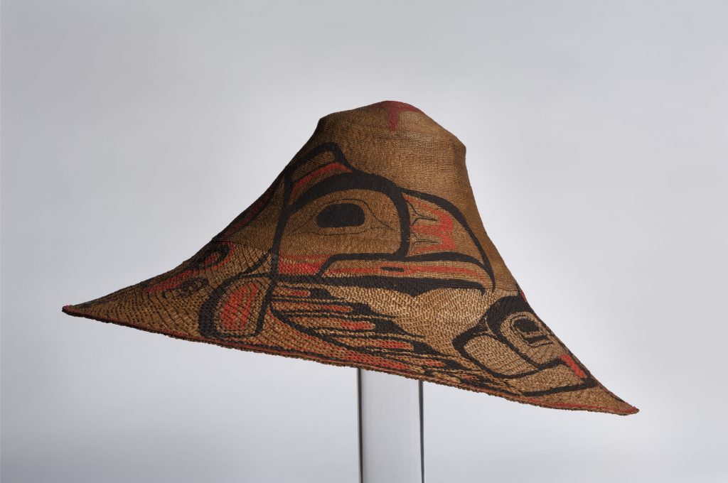
Slavery was, indeed, widespread and one feature of a social hierarchy that was reflected in housing, village organization, dress, and power. West Coast villages could be very large, dominated by cedar plank longhouses that could be as big as a football field inside. Stunning house posts and massive front panel designs announced the identity of the residents and their clan, as well as their powerful artistic traditions. An abundance of food made it possible for these societies to grow large and engage in substantial construction projects that required a lot of strong backs and limbs. They had the luxury, as well, of craft specialization, which led to expertise in weaving, loom work, toolmaking, and the production of beautiful personal and utilitarian objects. Villages were typically built on the foreshore in coves and bays, many of them atop clamshell middens that could be several metres deep. This signifies an effective food economy, and prosperity.
West Coast cultures are very different from other Indigenous civilizations and communities elsewhere across the continent, but some commonalities emerge. Even in highly settled areas there was some degree of population mobility. West Coast peoples moved seasonally to take advantage of resources in other sites. This meant the creation and maintenance of seasonal villages that complemented the more substantial “winter villages.” This necessitates having the time and equipment needed to relocate hundreds if not thousands of people a few times a year. Although Iroquoian villages were similarly large, they seldom moved. Across the rest of the northern half of North America, the numbers involved in seasonal migrations were significantly smaller. Parties of a dozen might characterize the basic unit of the Thule/Inuit community, although they would gather seasonally in much greater numbers. On the Plains, highly mobile communities consisted of about fifty people before the arrival of the horse on the Plains. This was fairly typical of Eastern Woodland Algonkian peoples and northern Athabascan peoples as well. The complexities of West Coast clan structures and systems of governance and lawmaking meant that place had nuanced meanings that further informed migrations. Villages everywhere included people born elsewhere, either within a lengthy family network or utterly unrelated to the host group. Mobility and a wide-ranging understanding of resource use and ownership—aspects of which we find in many Indigenous societies—profoundly informed the lives of West Coast and Cordilleran peoples. It is something that must be kept in mind when we consider the meaning of traditional territories in Indigenous societies over the last five hundred years.
There is another aspect to place that is worth mentioning. All of these groups modified their landscape in some measure. Some studies suggest that Indigenous farmers cleared much of the Eastern forests and encouraged the growth of large game herds by means of burning land so as to nurture grazing areas. On the West Coast, various peoples did much the same to encourage native plants like berries and camas bulbs, and to otherwise manage the supply of game. Evidence of irrigation canals in the American southwest, clam gardens on the West Coast made of carefully raised barriers, and stone eel weirs in the St. Lawrence system are all modifications designed to maximize food output while supporting sustainable stewardship of resources.[7] This scenario sees Indigenous people as the keystone species in the Americas, landscaping continents that were far from “pristine wilderness.”
Populations
The environmental events of the period between about 1000 and 1400—occurring at different rates and in different forms in different regions—brought an end to the largest agrarian societies in North America and affected the Pueblan communities in the Southwest as well. What followed appears to have been shrinkage in community size, a readjustment to new conditions, and the emergence of new alliances. What sort of numbers were involved?
This is one of the great unanswerable questions of Indigenous histories. Outside of the Mesoamerican civilizations and their peers further south, few societies in North America were in a position to keep track. Communities like Cahokia might have had the wherewithal to run a census, but the disappearance of mound-builder societies led to smaller, less bureaucratic, and less theocratic communities. Archaeologists and historians—often working with Indigenous collaborators—have attempted to build a picture of Indigenous demographics before ca. 1500 CE. The results have provoked much debate and little consensus.
For the past fifty years, however, the estimates have been moving upward. There are some outliers—too low and too high to bear much scrutiny—and some estimates that have gained increasing support. For the territory of what is now Canada, it is reckoned that a population of 500,000 meets several tests that satisfy scholars. This is five times the estimate accepted a century ago, but one-quarter of the estimate presently championed in some quarters. Of this half million, the largest share would have been living on the West Coast—where scholars’ estimates continue to climb. Population densities would have varied considerably, being highest on the West Coast and in the Iroquoian and Wabanaki farming villages. Small though many family and band units may have been at this time, seasonal gatherings—at Michilimackinac, for one—were huge and attracted thousands each year.
It seems likely that populations fell across most of North America during the collapse of the Mississippian cities. It is also likely that Indigenous populations were rebounding ca. 1500. We know that the Mourning Wars (described earlier) reflect a need to rebuild numbers; this may have arisen from spiritual beliefs, and it may also indicate that Iroquoian numbers were too close to the razor’s edge of unsustainability. This is, however, only conjecture, and it is highly probable that the rationale and objectives of the Mourning Wars changed over time. Developments beginning ca. 1500 would raise terrifying new questions about population and survival.
- Robert W. Venables, “The Clearings and the Woods: The Haudenosaunee (Iroquois) Landscape – Gendered and Balanced,” in Sherene Baugher and Suzanne M. Spencer-Wood, eds., Archaeology and Preservation of Gendered Landscapes (New York: Springer, 2010), 23. ↵
- Robert Park, “Contact between the Norse Vikings and the Dorset Culture in Arctic Canada,” Antiquity 82, no. 315 (2008): 189–98, https://doi.org/10.1017/S0003598X0009654X. ↵
- The term “Cree” derives from French terms (Kristineaux, Kiristinous, Kilistinous), which may, moreover, be descended from names given them by their Aboriginal neighbours. The Cree in the pre-, proto-, and contact eras can be described as three cultures: Swampy, Woodland, and Plains. Each of these had a variety of alternate names. The Swampy Cree, for example, appear in European documents as “West Main Cree” and “Lowland Cree,” and they describe themselves as Maskiki Wi Iniwak, Mushkegowuk, from which we derive Muskegon. There are eastern and western divisions within the Swampy Cree, which further complicates matters, as does migration across those two divisions. The Woodland Cree are similarly divisible between the Woods and the Rocky Cree, and nomenclature divides in this case between Sakāwithiniwak and Nîhithaw. The Plains Cree refer to themselves as Nêhiyawak. Given the enormous territory in which the historic Cree were dominant—from the Rocky Mountains to Labrador—it is unsurprising to find significant differences in identities among these Algonkian-speakers, even at the dialect level. There is, however, a historic and pre-contact continuity across the Cree range, and for that reason and to avoid confusion, the decision has been made to perpetuate the mislabel, “Cree,” when we describe the whole configuration of peoples. ↵
- Current and ongoing research suggests that herring -- rather than salmon -- may have been the coastal 'staff of life.' See Iain McKechnie, Dana Lepofsky, Madonna L. Moss, Virginia L. Butler, Trevor J. Orchard, Gary Coupland, Fredrick Foster, Megan Caldwell, and Ken Lertzman, "Archaeological data provide alternative hypotheses on Pacific herring (Clupea pallasii) distribtuion, abundance, and variability," PNAS, 111, 9 (March 4, 2014): E807-16. ↵
- Jesse Morin et al., “Late Prehistoric Settlement Patterns and Population Dynamics along the Mid-Fraser,” BC Studies 160 (Winter 2008/09): 9. ↵
- See Andrew Martindale et al., “The Role of Small Villages in Northern Tsimshian Territory from Oral and Archaeological Records,” Journal of Social Archaeology 17, no. 3 (2017): 285–325. ↵
- John M. Casselman, “Dynamics of Resources of the American Eel, Anguila Rostrata: Declining Abundance in the 1990s,” in Eel Biology, eds. Katsumi Aida, Katsumi Tsukamoto, and Kohei Yamauchi (Tokyo: Springer-Verlag, 2003), 259–60; William A. Allen, “The Importance of Archaeology in Understanding a Species at Risk: The American Eel as a Case in Point,” paper presented to the Ontario Archaeological Society 2007 Symposium, Kingston, ON (November 3, 2007), 1. ↵
